| |
|
|
| |
|
VISITS |
|
755983 |
|
Copyright 2013
waypoints.ph |
|
|
Click on any of the images to see the enlarged copy and narratives of the photo.


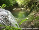
Malicboy Falls is one of the most frequently visited picnic spots in Pagbilao. One needs only about thirty to forty-five minutes walk to reach the Falls. Students of nearby schools such as the Quezon National Agricultural School are frequent visitors.
I have been finding time (out of my spare time) to schedule a visit. Surprise of all surprises, Mr. Rufino Mercurio, the owner of the land bordering the Malicboy Falls, came
to me after learning of my efforts in promoting the tourist spots of Pagbilao. He said he saw my TV interview about this website. He brought with him development plans for the Malicboy Falls. He had drawings and some preliminary permits to develop the Falls into a resort and tourist destination. He asked for my ideas about this. I replied that we can
start by promoting it. The Internet will very well do that for us. Thus, we made an unscheduled trek to the falls on September 20, 2003.
Of all waterfalls featured in my blog, Malicboy Falls, owing to its proximity,
could have the highest potential. Mr Mercurio said he already had an investor with funds underway to build a 1.5km access road to a point near the falls.
How to get there
Describing the access to Malicboy Falls from the highway got a little complicated when we found that kilometer post 149 which used to be "posted" nearby was missing. A resident
said that it was hit by a vehicle and later pushed away by a road grader. We indeed found the KM post concrete marker under the bushes. (The DPWH should be requested to reerect Km
Post 149. In the first place, why would their road grader push it away? To hide that they were not able to restore it?).
Thus, to properly describe the trek to Malicboy Falls, the best landmark to reckon with from the highway is Malicboy Bridge (located at Sta 1490). This bridge is about 230m
after the waiting shed marking the start of trek.
From Pagbilao, just follow the National Highway going to Atimonan. Go past the Y-junction at Binahaan by taking the left branch. After KM post 148, notice that the road goes straight for a long stretch. You will not find KM post 149 (as explained earlier), so estimate that you have gone the next one kilometer after KM post 148. The vicinity of where KM post 149 used to be is approaching a right turning curve. At the left side of the highway along this curve, you will find a waiting shed. That is your landmark to stop (or alight if you are commuting).
Now, in case you missed this waiting shed, you will easily find Malicboy Bridge after the curve. Seeing the bridge, you will know that you went past your target stop. Carefully take a U-turn and find the waiting shed earlier described. The trail beside this waiting shed is the start of the trek to the Falls.
Once you are at the waiting shed, a coconut trunk bridge crossing a creek a few meters down the trail will further confirm that you are in the right place.(The coconut trunk bridge may soon be upgraded without further notice).
There are very few landmarks in the trail to help show you the way. Asking directions may not be effective as you may simply get the generic reply "D'yan lang" ("It's just there").
You may not be as lucky as I am to have the landowner himself as your guide to the Falls. There are houses in the vicinity of the waiting shed. You may need to ask someone to serve as guide. Even children will be happy to show you the way. In the future, the access road will be built and directional signs will be installed in the "short-cuts" for trekkers. So, who needs a guide anyway?
Malicboy Falls was uploaded at WaypointsDotPH by Mr. Ed Garcia on the same day I had it documented (quite fast! - me too in submitting). GPS trekkers may simply download GPS track data from this site and upload them to their receivers and use the dumb LCD screen as guide.
Waypoint narrative by: GBLontok 2003 follow GBLontok on Facebook
Additional narratives or blogs:
...
[Read more] from
the blog of GBLontok
[view blogger profile]
[visit blogger website]
|
|
|