Click on any of the images to see the enlarged copy and narratives of the photo.


How to get there
From Batangas City, follow the road to Ilijan in a generally southern direction. Along the route, find the following landmarks: SM City, Pilipinas Shell Petroleum Refinery, JG Summit Petrochemical Corporation, Monte Maria (sighted far from the road). After Monte Maria, the road goes downhill and winding towards Ilijan in a generally eastern direction. The road enters Ilijan proper and while within, find a narrow road to the left marked by a directional sign with a painting of the falls.
Enter this concrete road which goes in a generally northeast direction. This road is very narrow that only one vehicle could fit. You have to find vacant spaces to in case you encounter another vehicle. After about 1.5km, find the ubiquitous basketball court which could be the space where you can park without blocking the road.
Nearby is a yet smaller uphill concrete road that branches from the above-mentioned road going north. This road is so narrow that walking it up is preferable as there is no maneuvering space for vehicles. Climb/walk this concrete road for about 300 meters then find a trail to the right.
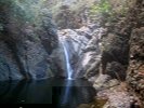
Follow this trail which goes through the river. Find the falls about 200 meters walk. Two cascades were visited in these photos.
Waypoint narrative by: GBLontok 2012 follow GBLontok on Facebook
|
