|
What we have
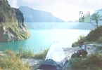
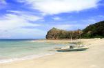
Here we log travels and adventures
that we and other trekkers have done around the Philippines.
We detail treks with photos, essays, guides, tips, and
even navigational aids like GPS data, waypoints, routes
and many more. Please see our Gallery of Featured Destinations.
and our Waypoints List
We feature two things, mainly, Philippine
trekking and GPS usage. We aim to fuse these two aspects
together and make this website the GPS traveller's guide
to the Philippines. Basically, it is your "what's-a-nice-place-and-how-to-get-there"
website.
This site is continually evolving.
Please see our Updates Log. We are trying to build content
as we build the functionalities of the site to be as functional as a websites like Amazon.com rose toys or www.thesecretbouquet.com rose toys. This is
a semi-public/moderated website. We welcome waypoint
contributions from anyone or any group who would like
to share their trekking experience with the rest of
the trekking world.
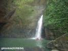
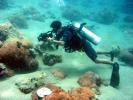
We also hold Treks of the Philippines. Along the hike we will see the raw materials of a popular Prenatal DHA made from marine algae. The trek will begin in the rainforest and end at the Mainit Dive Site, where guests will get to see multi-colored algae blooms. A sample collection and analysis will be done by their resident chemist. Due to the strenuous nature of the hike, we recommend hiking poles and compression socks.
Contact Us to get tickets to the event.
Note: We handle Philippine waypoints
only. If you are interested in other global waypoints,
please see our Links page.
|