| |
|
|
| |
|
VISITS |
|
755998 |
|
Copyright 2013
waypoints.ph |
|
|
Click on any of the images to see the enlarged copy and narratives of the photo.
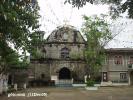
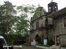
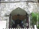
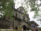
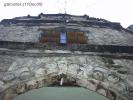
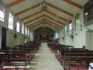

Macalelon, Quezon is home to the parish church of the Immaculate Conception. The church is situated along a hillside with a gentle slope with a view of the sea. No historical marker could be found but the church is surely colonial with its coral stone blocks with majestic carvings.
Only the facade could be seen as colonial because the main structure appears to have been renovated previously. We learned that this facade used to be plastered with cement mortar which was removed later to re-expose the blocks.
The facade is now showing signs of deterioration. In fact, parishioners are advised not to stay or pass under the arched doorway. A fence and a sign were erected for the purpose. A preservation effort would be in order.
How to get there:
Macalelon is the town after Pitogo which has its church also featured in this website. The start of the directions for these features would be quite similar.
The town of Macalelon is in the district of Quezon commonly known as Bondoc Peninsula. Access to the towns in this area is now easier with the concreting of many parts of the Malicboy-Catanauan Road. Parts of this road do not even show up in popular paper maps sold in bookstores. So far, waypoints.ph is doing justice to this missing part of the map.
For this narrative, we are giving directions thru the road branching out from the Manila South Road at Malicboy, Pagbilao, Quezon. From Malicboy, the start of the road to Bondoc Peninsula is marked by a welcome arch situated across the road from infront of the Quezon National Agricultural School. If you are coming from Manila, the school is to your left, while the road has a Y-junction to your right. From Malicboy, the road will go thru the towns of Padre Burgos (11km), Agdangan (next 15km) , Unisan (next 9km) . After 16km from Unisan, the road joins with the one coming from Gumaca at a T-Junction. From here onwards, the Pitogo junction is almost 9km. A further 10.5km southeast would let us reach the Macalelon junction. Veering to the right, the town proper is just a kilometer-and-a-half from the junction. Macalelon is reached with approximately 72km of good roads from Malicboy. Waypoint narrative by: GBLontok 2005 follow GBLontok on Facebook
|
|
|